 Live Music Archive
 Librivox Free Audio
 Metropolitan Museum
 Cleveland Museum of Art
 Internet Arcade
 Console Living Room
 Books to Borrow
 Open Library
 TV News
 Understanding 9/11
tv Huckabee FOX News October 28, 2012 8:00pm-9:00pm EDT
8:00 pm

storm category. and maria molina, thank you. that's how fox reports on sunday, october 28th, 2012. i'm harris falkner, keep it online, foxnews.com and your other source, geraldo, two hours of special storm coverage starts now. >> this is a fox news alert. i'm geraldo rivera reporting on the epic superstorm bearing down on a huge swath of the northeastern united states potentially threatening the property and disrupting the lives of tens of millions of people in the most halfly populated corner of the country. humps of thousands of those living in low lying areas from delaware to new jersey, new york to connecticut, are already under orders to evacuate. because of the real dangers posed by heavy rain. high winds, and a flood surge that could shove a tsunami like wall of water into new york and other area harbors. and mass transit throughout
8:01 pm
this area has already been shut down. schools, libraries, many government offices and private businesses will be closed on monday, including the traders at the stock market and broadway, the great white away is already dark and the streets are already quiet, as the city that never sleeps hunkers down in the face of sandy's franken-storm, the wicked pre-halloween collision of a tropical hurricane with a wicked storm coming from the west and frigid air, arctic care coming from canada and the danger is not limited to the coastal area. it's feared the coming mega-storm will spread half vick from north carolina, to kentucky, virginia to west virginia, to pennsylvania all the way to the east coast to the great lakes. there will be inland flooding, downed trees, widespread power outages, and impassable streets in many areas. and bear in mind, hurricane sandy is already a killer storm, having claimed almost
8:02 pm

60 lives in jamaica, cuba, haiti and tbahamas. and here is our special coverage of the mega-storm of 2012. here outside fox news world headquarters in manhattan this is the literal calm before the storm. it's chilly, breezy, but so for it's a dry night. bands of rain are approaching the new york city area, extremely high tides expected, wind gusts up to 70 miles per hour, and are expected before this time tomorrow. but they're not here yet. millions of people here in the city up and down the northeast coast are hunkered down already, they're at home or with friends, or family, or they're in public shelters. the shelves of many stores have been shopped bare in anticipation of this enormous storm which unlike a
8:03 pm
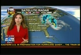
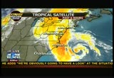
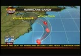
traditional hurricane will be an enduring event, stretching perhaps into thursday. there are flood warnings as i said, high wind warnings, and maria molina, the hardest working person in the news business is here to tell us everything we need to know when and where the storm is going to hit. okay, maria, when does it come to new york? where is it now? who are the first people impacted? >> right now the center of sandy located just thigh south-southeast of the the new york city area, pretty far away and we're not expecting sandy to make landfall across central new jersey until tomorrow night. and pretty late at night, the later evening hours and we're already seeing some of the the heavy rain bands outside of the new york city area to the west across eastern portions of pennsylvania, through portions of maryland, down through eastern portions of the state of virginia, and also, north carolina, and spots out there have already picked up over half a foot of rain so we're' experiencing flooding out there and to the west of the system, our
8:04 pm
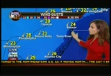
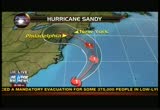
frontal system that's going to be colliding with sandy's already bringing in rainfall across ohio down into portions of eastern kentucky and both of the systems as we head into tomorrow and tuesday, colliding and producing all kinds of chaos and the winds are picking up across portions of long island. even though sandy is far away, it's outwards from the center of the storm, up to 520 miles and we're already seeing some of the wind gusts shy of 40 miles per hour, across places in long island, new york city, seeing wind gusts shy of 30 miles per hour, and further south across new jersey, the same story, 29 mile per hour wind gusts across the atlantic city and as far inland as baltimore, we're seeing some wind gusts rise over 20 miles per hour and the forecast continues to increase here as we head into tomorrow and early tuesday morning, and landfall, still expected across central, southern new jersey as we head into late tuesday night and early, or late monday night and early tuesday morning and maximum sustained winds there, forecast to be at 75 miles per hour, and the center is coming
8:05 pm
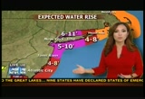
across central new jersey is pretty much the worst case scenario as far as the storm surge for the new york city area and long island sounds expecting water levels as high as 11 feet and new york harbor up to ten feet and both of the water areas will be colliding across the east river, east of manhattan, and producing all kinds of flooding and that's why mayor bloomberg did issue evacuations for zone a across the five boroughs of the new york city area, and sandy is a large storm again, geraldo, other areas will experience water along the coastal area, and big area of the northeast at least 48 hours of high winds, so trees will be down, power outages expected, also for millions, or many people. geraldo. >> geraldo: maria, i'm hearing it will be the highest surge ever since this have he' been keeping track since the 1820's here in new york. and that it's already started snowing inland.
8:06 pm
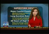
what do you know about that? >> well, as far as the forecast,dy see one model that issued basically an elevated rise in water level as high as 11.7 feet, right across the lower parts of lower manhattan which would break the record last set in 1960 as far as the highest level of water recorded across that area of new york city and as far as the snow goes, not just yet, but there was a blizzard warning that was issued across parts of west virginia, basically and that goes into effect across basically monday afternoon into early wednesday morning, locally up to two feet will be possible, but it's not just the amount of snow, but the fact we're pretty early in the season. it's not winter just yet and many trees still have leaves on there so that could be bringing down some trees and also the strong winds in combination with the snow will produce white-out conditions, very cool temperatures along with power outages, means very dangerous conditions for many people out there across the state of west virginia. >> geraldo: so, maria, what time does it hit new york? you've got to tell me. >> central new york where the center is forecast to go and
8:07 pm

late tomorrow night, basically around 9 p.m., 10 p.m., so we don't want to focus on where the center is going or what time because again, sandy is very large and spans over 800 miles from one end to the other so we'll be feeling the impacts for quite some time. >> geraldo: i'll be speaking with you as the evening progresses, maria molina our crack meteorologist in the fox news extreme weather center. and north carolina has been getting rain and some wind already. grier beaty, the director of north carolina department of transportation, so, grier, tell me what you've experienced so far and if you can, let me know what kinds of damage you've seen. >> well, we've seen a good bit of flooding and over washout on the outer banks. the nc-12 is actually closed from the oregon inlet bridge, to the-- oak cokrcracoke island is experiencing flooding and
8:08 pm
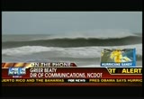
there's plenty of water, lots of overwash, lots of sand being moved around and we still have hours and hours to go. >> geraldo: so what is your biggest fear, is it water or wind, grier? >> i think it's a combination of the two, i mean shall the wind blows the water, but ultimately the water is what does the biggest damage to the roads. so, as the storm continues to just kind of churn away for hours, we're going to be looking to see what kind 6 damage there is in the morning, when we can get out-- i mean, the bridge at the inlet we're going to have to send some divers to do inspection as soon as the condition allows, because it's, you know, it's closed. >> geraldo: i'm sorry, we've got fire trucks and they are he' moving out and not sure exactly what's going on. the police commissioner here in new york will be joining us momentarily. listen, we'll continue to check back with our friends with you all down in north
8:09 pm
carolina, that as it comes up in the mouth of the chesapeake, that area, delaware, maryland and virginia all come together and worked its way up. we'll be tracking it, thank you, and checking back with you there in north carolina. ladies and gentlemen, we've got assets up and down the coast and inland. this is for real, it's a monster storm, new yorkers have a tendency to take things kind of casually, but they really are hunkering down in a surprising way. these warnings really have been heeded and we'll talk to the police commissioner and he'll tell us how the hundreds of thousands of people have already been evacuated from their low lying homes are, you know, are weathering this storm. that's what we're doing, we're weathering the storm and giving you the very latest on hurricane sandy and this megastorm, this perfect storm and how many people will be affected and when and how badly. we'll be right back after this. i have a cold... i took dayquil,
8:10 pm

but i still have a runny nose. [ male announcer ] dayquil doesn't treat that. huh? [ male announcer ] alka-seltzer plus rushes relief to all your worst cold symptoms, plus it relieves your runny nose. [ sighs ] thank you! [ male announcer ] you're welcome. that's the cold truth!
8:11 pm

thank you, mr. speaker, uh, members of congress. in celebration of over 75 years of our government employees insurance company, or geico...as most of you know it. ...i propose savings for everyone! i'm talking hundreds here... and furthermore.. newcaster: breaking news. the gecko is demanding free pudding. and political parties that are actual parties! with cake! and presents! ah, that was good. too bad nobody could hear me. geico. fifteen minutes could save you fifteen percent or more on car insurance.

8:13 pm

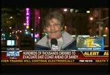
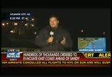
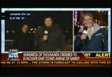
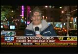
>> your he looking live at the crossroads of the world times square, new york. sunday evening performances canceled and monday performances cancelled and schools in new york and enviens shut down and flood warnings manhattan and coney island brooklyn, i've heard some evacuations going on in greenwich, connecticut and hundreds much thousands evacuated. the subways are already closed in anticipation of what they fear will be high widespread power outages. so, the subway is closed. the bus system here in new york will shut down in about 47 minutes, at 9 p.m., so, all of mass transit, the amtrak, everything, will be completely
8:14 pm

shut down. thousands of flights have been canceled. the stock markets, the first time since 1985 there will be no trading on the floor and the national guard and in the area has been mobilized and all of the states here in the northeast, the governors have declared states of emergency, atlantic city, they've shut down the casino. not to mention, remember that little thing, going to happen a week from tuesday, november 6th, the election for the presidency of the united states, well, that, too, has been disrupted and we'll talk about that a lot. sandy, as i mentioned, is heading north. heading toward both chesapeake and the delaware bay area with delaware bay in its sight. let's go to rehoboth. doug, what do you anticipate? >> you last came to us, things have worsened somewhat, geraldo, i don't have an anamometer to measure the wind
8:15 pm

speed. but i have an unofficial measure. the stinging sensation in your face from the drops, that's the first time i've felt that today and the second thing the waterproof boots i bought at a popular national chain store claiming to be waterproof are sloshing wet and my socks are sloshing around in them. the good news here is that high tide happened at 7:32. the highest wave came to where i'm standing here on the top of this dune and did not go any further. if you walk another ten yards or so over the little fence here, then you get to the boardwalk. and this is high and dry, at least from sea waters. plenty of wet from rain. remarkably i told you we'd show you sound from youngsters that took their boogie boards out at dusk. i called them to come back in to talk to them. >> no one is going to come rescue you if you're taken out. >> that's why we're sticking
8:16 pm

together. >> if your mom and dad knew you were doing this, what would they say. >> they're up there watching. they drove us down there. >> their parents were watching them doing that from the pickup truck parked beyond the boardwalk. this storm is nothing to be messing around with at all and the governor of delaware made that point to us when he came by the hotel. here is what he had to say. >> mother nature is very powerful, we're doing what we can, but i think this is a recognizance heck of a storm and we're seeing what we see behind us now, the fact is this storm is hundreds of miles away and it's still pretty bad out here. >> indeed, hundreds of miles away and as i say, the winds are beginning to pick up right now. we know that the fleet, the naval base, it had gone out to see and a better chance of surviving a storm out at sea, believe it or not, rather than in the port and we've seen measurements from buoys out at sea and wave heights as high as 34 feet. here in close at the surf of, i would estimate some of the waves as high as ten to 15 feet so we survive the high
8:17 pm

tide at 7:32, and more high tides, roughly at seven o'clock and seven or so in the evening and we'll he see what that is, we'll be standing by. >> and doug, we'll check back with you, as the evening progresses and one of the problems, ladies and gentlemen, i stood in this very spot a year ago for hurricane irene. there were some similar dire warnings then, and when the storm came, it actually leapfrogged over new york city and landed further up the hudson river and caused considerable damage there, although we didn't know it as the storm was happening and one of the things i've learned in 40 years of coverage these events is that it is always worse than it initially seems because you begin to tally the damage once daylight comes and once things get more calm. but this will not be like a traditional hurricane, this will not be something that happens in six or eight hours and then we're on with our lives and this is an enduring event, it is the collision of
8:18 pm
the three big weather systems, the tropical hurricanes, the frigid winds coming down from the north and that western low pressure system, everything's going to get churned around and it's going to be part of our lives, unfortunately, for several days, and i think, i fear that before this is over, it's going to be a story with many, many tragic ramifications. but stand by, we're going to give you the latest and the very best information we can. we'll be right back back after that. [ female announcer ] need help keeping your digestive balance? try the #1 gastroenterologist recommended probiotic. align. align naturally helps maintain digestive balance. ♪ ooh, baby, can i do for you today? ♪
8:19 pm

try align today. you on the company phone list that's a few names longer. you see us bank on busier highways. on once empty fields. everyday you see all the ways all of us at us bank are helping grow our economy. lending more so companies and communities can expand, grow stronger and get back to work. everyday you see all of us serving you, around the country, around the corner.
8:20 pm

us bank. smoothest riding. it's got the most torque, the smoothest suspension, the best storage, class-leading comfort, and a revolutionary collection of versatile accessories. introducing the all-new, 60 horsepower ranger xp 900, a whole new class of hardest working, smoothest riding. get huge rebates on 2012's and low financing on all models during the polaris factory and loauthorized clearance.dels
8:21 pm

>> welcome back live. we're tracking the mega storm. hurricane sandy and her diabolical allies and the mess they're going to cause.
8:22 pm

joining me now, a man who not only has the lives of 8 million new yorkers as his responsibility, but he also keeps the peace and safety of the world capital, the city that never sleeps. i welcome right now the police commissioner of new york, raymond kelly. remember, commish. >> great to be with you always. >> geraldo: so, what, what a storm. you know, the evaluation, first of all, tell us how that went and how people responded. >> well, it's still ongoing, no question about it. there's potentially 375,000 people in the, what we call zone a for evacuation area in new york, so it's ongoing and we understand that everybody is not going to evacuate. we'd like everybody to do that, but some people are going to remain behind. and we ask people to use common sense. this is a-- going to be a tremendous one and the side and breadth we haven't seen for many, many
8:23 pm

years. >> geraldo: do you worry that people living through irene with so little damage here in new york, we had great preps, but very little damage, that people will be resistent or reluctant to talk measures that they should? >> yeah, some people will and obviously we're trying to get the message out that from all indications this is going to be an unprecedented storm. so, we want people to be prudent and we want people to use common sense and you know, we understand that it's going to be inconvenient. we know that the transportation now basically has been stopped. so, we ask people to consider themselves and also consider first responders. if you put yourself in a dangerous situation, ultimately first responders may have to go in and risk their lives in an effort to rescue those folks, so, they are he' all in it together and let's all work together and get past it. >> from a law and order point of view, what's your biggest worry. >> well, your he' always concerned when people leave
8:24 pm

larger areas of the city. we have a -- a regiment in place that we believe will protect those areas and we haven't seen in the past any significant outbreak of crime. and people understandably are a little bit concerned when they're leaving their property. but we haven't seen, you know, an outbreak of crime in the past. >> you guys get the best up to the minute briefings. you're also, you know, a combat, united states marines among your other credentials and how real is this in terms of the danger that it poses to this region? >> we think it's real. everybody's at-- that i talked to, obviously, the hurricane center, the national weather service, these folks are tell us that this is the real deal. and they're very much concerned about the size, the breadth of this storm, up to 500 miles in area that it's covering and even if you're not in the actual track of it, you're certainly going to be affected hundreds of miles
8:25 pm

away, so, all the indication are are this is the real deal. but, you know, there's no guarantees here, let's all get together and get past this. >> one thing i have to mention is, you've got to run for mayor, commissioner, you know, and when mayor bloomberg retires you can't leave the city in a lurch. >> i've run into this job every day, they're after me every day, well, we're backing you, geraldo, thank you very much. thanks for all you've done for your service and keep it safe. and give awus a minute. the old demignon ahead of the storm, we have plenty of political news coming your way. and shall we go to aaron? let's go to aaron right now from real clear politics in cincinnati tonight in the battle ground state of ohio. erin, i've been seeing you on tv. you do a terrific job. thank you very much for being with us.
8:26 pm

first of all, how disruptive of politics is this weather event? >> very. look, all of the events in virginia, from sunday, today, going forward have been canceled. all of the events that mitt romney, that vice-president biden, that the first lady were going to have in new hampshire as well have been canceled and even president obama isn't going to ohio tomorrow. he's going to let bill clinton, the former president campaign for him in youngstown, ohio instead. it looks like mitt romney is going to be hunkering down in ohio a state he needs to be better in. president obama is going to be stuck at the white house. and he went to florida tonight so he could be in place for a rally tomorrow. he may regret going there at all because he'll be coming back to the white house to monitor the storm, but it's going to be halting a lot of political activity going forward into wednesday. maybe even thursday, but right now the white house is looking at canceling even more events, potentially another event that the president was going to be having in wisconsin on tuesday night. so, it looks like we're coming
8:27 pm

to a stand still for a couple of days here. >> geraldo: so, you have both governor romney and president obama trying to balance the fact that the election is eight, nine days away, with the, first of all, the perception that they have to be paying attention, they have to be-- the president literally has to be there in command as commander-in-chief, it's a very, very difficult balancing act for them and it comes at a time. i have the polls in front of me, erin, i'd like to run over with you. first of all, we have the gallup daily tracking poll today that shows governor romney up by four points, 50-46. you have the rasmussen daily tracking poll that has governor romney up 50-47. the real clear politics average though is closer, that has 47.7 for governor and 46.8 for president obama, so, erin, real clear politics, you guys have this as a virtual dead heat? >> we do. in the national polls right
8:28 pm

now, it looks like mitt romney is ahead. he's poised to have a victory in the popular vote, if the election were held today. but if you look at the a lot of the state polls, it looks like president obama is headed for a victory in the electoral college. it may be that the hurricane, the big storm is the october surprise that could swing the election either way. but president obama is tracking ahead of mitt romney in many of the important swing states and the big question is, does president obama stop campaigning because will he take a big political hit if he starts doing some of that? and mitt romney has to worry about going into any of the the other states that will make him look too political for campaigning in the middle of the storm. that's the big question na we're facing right now. but right now president obama is ahead in the state whereas mitt romney is ahead nationally. >> geraldo: erin, quickly, i've got 30 seconds, florida has romney over obama by 1 1/2, more or less. virginia has romney obama
8:29 pm
tied. ohio has obama over romney 48 funny 2 to 46.3, wisconsin has obama over romney by 2.3 percentage points so ladies and gentlemen, erin says that the governor is on track to win the popular vote, but as of right now, the president looks likes he's ahead in the electoral college. we have to take a break and we'll continue our special coverage of the storm, and the political storm and a bit later benghazi-gate. don't go anywhere, the wind is beginning to pick up here in manhattan. 4g lte is the fastest.

8:31 pm

so, which supeast 4g lte service would yochoose, based on this chart ? don't rush into it, i'm not looking for the fastest answer. obviously verizon. okay, i have a different chart. going that way, does that make a difference ? look at verizon. it's so much more than the other ones. so what if we just changed the format altogether ? isn't that the exact same thing ? it's pretty clear. still sticking with verizon. verizon.
8:32 pm

more 4g lte coverage than all other networks combined. >> time for evacuation is over. everyone should now go inside and be prepared to stay inside until weather conditions improve, which won't likely be until sunday afternoon. >> hurricane irene. it was last year's monster storm of the century. >> and then when we put in--
8:33 pm
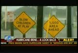
>> officials warned of catastrophe. >> i saw some of the news feeds watching upstairs of people sitting on the beach in asbury park. get the hell off the beach in asbury park and get out. you're done. it's 4:30 you've maximized your tan, get off the beach. >> we've never done a mandatory evacuation before and wouldn't be doing it now if we didn't think this storm had the potential to be very serious. >> geraldo: irene was bad, but not as devastating as expected. so some fear now to skeptics will not heed warnings and remember how many areas last year did take a beating. >> i knew it was going to be bad, but didn't anticipate seeing this here off the shelves. >> destruction and mayhem and it's hard to do your job, you feel bad because i am pea a family man myself, like i said destruction and mayhem. >> there was widespread flooding. >> some people didn't take the warnings when the storm surge
8:34 pm

first hit we were rescue being people out of their houses by boat. by tag lines and sending in firemen in chest deep water to their houses. >> millions without power. >> i've been here 16 years and i've never been without power this long. >> some for weeks. >> it's going to take a long time, now? it could be months, it could be years to get the roads back the way they were. >> geraldo: even months. >> folks cannot just return to their homes, even if they want to. the flood waters may be resident in basements and taken out pilot lights and could be gas emitted in the very properties as we speak. >> geraldo: that was then, this is now, and hopefully people will heed the current warnings, this storm is the not like irene, as i said this is not a traditional hurricane, this is a megastorm, down to the south and west of us, new jersey, facing widespread flooding. brother craig is down near atlantic city. tell us exactly where you are and what's going on there. >> all right. geraldo, we're in ventnor city
8:35 pm
just down the road from atlantic city and behind me is the intercoastal waterway, now, it's the low lying areas of the jersey shore where people are most at risk. they're directly in the path of the storm. now, we're not expected to feel the full effect of hurricane sandy for another 24 hours when sandy makes landfall, but we're already feeling the outer bands of the rain and the wind. now, with the astronomical high tides, these homes behind me are already at risk. when the storm comes ashore in the delaware area combining with the two winter storms, becoming that hybrid monster storm,s tides are expected to be ten to 12 feet above normal. now, in the atlantic city area, where tens of thousands of residents have been ordered to evacuate, there's a problem. a lot of the residents have refused to leave, despite governor christy's order. earlier today, i spoke with the atlantic city mayor
8:36 pm
lorenzo langford about the dangers of riding out the storm. this is a very, very precarious situation, not to be taken lightly or played with, we've urged all of our residents to vacate the city and take every measure possible to find habitation outside of the confines of the city of atlantic city. my biggest concern is we will get so much water in the city that those who decided not to heed our warning and to hunker down, we won't be able to get to should we need to. >> yeah, okay. so, geraldo, you'll with joe doherty, he's a lifetime resident in this area. joe, i was with you during hurricane irene and this seems like it's much worse. >> it does seem worse already. it was high today and higher now. >> why aren't people leaving? >> well, it takes a long time to get the long time residents off the island and last year
8:37 pm
there wasn't as much damage as expected and-- >> this is bigger, stronger and much more dangerous and already seeing the water hit against the docks and much more damage. >> it does and tides are pretty high and again, it's two times day and the water will run out and people are fairly comfortable staying the ones that have stayed they've been here a long time. >> well, best of luck to you. geraldo, joe is having a storm party in anticipation of sandy arriving and hopefully spirits will stay up. back to you geraldo. >> geraldo: safe me a rum drink, brother. okay? it sounds okay. and listen folks, this is for real. now, the real danger, i have a dock on the hudson river. i have-- i'm telling you that, i fully anticipate my dock to be over, over run by the river, as it was last year. but this last year was, i think, a three foot storm surge up the river and now they're anticipating between six and 11 feet so it's going
8:38 pm
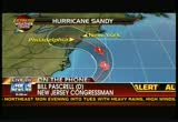
to be devastating and right now my congressman, bill pascrell, the democrat in burgeon county. congressman, are we ready this time around? >> this is a whole different ma gilla, my friend. and particularly the tri state governors have done a fantastic job preparing us, along with fema. i just talked to the national weather bureau a little while ago because we've been briefed every six, seven hours. they say they've never seen a hurricane become a nor'easter and then turn right into the coast. so it's no exaggeration, and it's 75 miles at the shore, and it's going to sit which makes it even more dangerous, and we're going to get four, six, seven inches of rain, and the ground will be swollen
8:39 pm
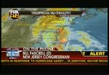
with water. and going to be particularly vulnerable. this is the real thing. please listen to the president, the governor of new jersey, new york, these are serious situations before us. this is not going to be simply a storm that goes by. it's going to go by because it's so big, it's going to go by and take many, many, many hours to get by. that's how big it is. so, we've already september a letter supporting the governor's request for federal disaster declaration and new jersey by congressman chris smith, who is the-- >> what happens during tomorrow's commute? are people going to attempt to go from new jersey here to manhattan? or do you think that they, the garden state is going to hunker down? >> i, i think we're going to hunker down. i would not ram anybody in the
8:40 pm

tunnels, for instance, the holland tunnel is particularly vulnerable. i would i wou i would-- i wouldn't be surprised if it's closed and flooding occurs, and now of we've got multiple factors and i would say tomorrow's a day we better stay home, that's what i would recommend. >> geraldo: a good day of rest, good advice, congressman bill pascrell. and congressman robert andrews. >> you're welcome. >> geraldo: another democratic congressman from new jersey joins us now, congressman andrews, what are you telling your constituents in terms of what they should be planning on doing tomorrow. we're telling them to listen, as bill just said, to the president, the governor and law enforcement first responders. only travel when essential and necessary. the public transit systems-- my constituents a lot of them work in philadelphia and the public transit systems have been shut down going into philadelphia. the casinos in atlantic city have been evacuated, just mayor langford you had on a few minutes ago, all the barrier island has been evacuated.
8:41 pm

so what we're saying to people is take this seriously, travel only when absolutely necessary. >> geraldo: so, if you can restrict travel, i guess, all the schools-- are all schools private and public closed in new jersey, congressman? >> in my area, yeah. >> geraldo: so they're shut down and what about the public offic offices, people who work for the municipalities or the states? >> the essential people are coming in, the first responders and public works, but by and large those folks are shut down. the colleges and university are shut down. rutgers university on our end of the state. rowen university, really only those who must be out to help the community are going out and rest of us should frankly stay home and be safe. >> geraldo: want to give me 30 seconds, congressman, how this is affecting reelection efforts? >> i think this is far from politics as you can get. i don't think it should have anything to do with politics, we should make sure we keep our community safe and worry about the election next week. >> geraldo: congressman
8:42 pm

andrews, i appreciate it. thank you very much congressman pass cell. and we'll be back with much more after this. bob...
8:43 pm

oh, hey alex. just picking up some, brochures, posters copies of my acceptance speech. great! it's always good to have a backup plan, in case i get hit by a meteor. wow, your hair looks great. didn't realize they did photoshop here. hey, good call on those mugs. can't let 'em see what you're drinking. you know, i'm glad we're both running a nice, clean race. no need to get nasty. here's your "honk if you had an affair with taylor" yard sign. looks good. [ male announcer ] fedex office. now save 50% on banners. yeah, i might have ears like a rabbit... but i want to eat meat! [ male announcer ] iams knows dogs love meat. ...but most dry foods add plant protein, like gluten
8:44 pm

iams never adds gluten. iams adds 50% more animal protein, [ dog 2 ] look at me! i'm a lean, mean flying machine [ dog 1 ] i am too! woo hoo! [ male announcer ] iams. with 50% more animal protein. [ dog 2 ] i'm an iams dog for life. not a rabbit. woof! to compete on the global stage. what we need are people prepared for the careers of our new economy. by 2025 we could have 20 million jobs without enough college graduates to fill them. that's why at devry university, we're teaming up with companies like cisco to help make sure everyone is ready with the know-how we need for a new tomorrow. [ male announcer ] make sure america's ready. make sure you're ready. at devry.edu/knowhow. ♪

8:46 pm

headquarters. 24 hours from now, where i'm standing will be awash with driving rain and very intense winds. and you know, new york, four of the five boroughs of new york are on an island. you have the queens and brooklyn on long island and you have the island of manhattan and staten island so we're very much influenced by the weather. if manhattan is my hand, the microphone is long island. long island is a real barrier to the south coast of long island, very low lying, very sandy. the winds coming off the atlantic ocean really have a severe impact there. many of those communities have also had mandatory evacuation orders. and our anna kooiman is now in long beach, new york. anna you can give us, first of all, what are conditions like right now. tell us, if you can, what communities have been impacted in terms of evacuation orders.
8:47 pm

>> right, well, geraldo, i can tell you i'm from north carolina and i've covered a lot of hurricanes. this is definitely the coldest, chilliest hurricane that i've covered, that's for certain. and, but nassau county, right now where long beach is under mandatory evacuations for all low lying areas and the storm surge zones, in fact, here on long beach, the bridge is actually closed to all incoming traffic, unless you're somebody like a first responder or a member of the media. so, they have been asking people, of course, to get out, please don't come in and a lot of people have been heeding those warnings partially because of what we experienced with irene just pummelling this area last year, all across the northeast, but really here on long beach there were points where actually the bay was touching the atlantic city. and people simply don't want to be dealing with that type of situation this go round. and this storm of course, is going to be a monster and expected to be just a whole
8:48 pm

lot worse. the red cross has been setting up shelters and do have those in place and existing residents who are bracing of course for the strong winds, the heavy rains and this storm surge. the long beach city buses and also we've learned this evening, they have he' been running and the normal routes that they've been picking up residences and shuttling them to shelters and a pet friendly shelter and bus. and the water picking up all day and the angry ocean has a lot of spectators coming out to the boardwalk earlier today to check it out and surfers of course enjoying the ride of a lifetime for them. of course, the best thing to do though, get out of town. also, reminiscent of irene last year, new york city bus service and rail, that's suspended and happened at seven o'clock tonight, and the mayor of new york city, michael bloomberg also mentioning that 1.1 million
8:49 pm
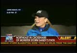
students in the city system are not going to class tomorrow, and the new york stock exchange will be opening, actually, geraldo. >> geraldo: yeah, the stock exchange will be open, but they won't be trading, i think they do it electronically now. and right now what's the ocean look like, i know it's dark, you can't give us a shot, but why don't you describe what the condition is behind you. >> well, i can tell you that it really has been creeping up and part that have is because high tide was at seven o'clock. and so, we've been watching it creep closer and closer and of course, our hotel is right here, against it. we're worried that the waves are going to start slamming into us and the barrier that they've created, hoping that it will, you know, try to stop some of that storm surge, but it's definitely gotten whiter as well, as the waves have started pounding the coast, geraldo. >> geraldo: and how are the folks heeding the orders? are they listening or skeptical? >> well, you know, we've seen
8:50 pm
both. you know? we've seen a lot of people in the hotels actually who said that they think that this place is safer than where they were and that's one of the reasons why they've come here rather than getting off the island completely and it's the kind of thing where these people have grown up and been through storms before, but if you listen to the meteorologist, look, they're forecasting, this is something a lot of folks have not ever seen in their entire lifetime. >> geraldo: anna kooiman, that's for sure. thank you very much, anna, we'll check back as the evening progresses and ladies and gentlemen after this short break we'll get to a storm chaser and we'll find out what it's like when, as this thing begins its approach to the united states after this. i have a cold, and i took nyquil,
8:51 pm

but i'm still stubbed up. [ male announcer ] truth is, nyquil doesn't unstuff your nose. what? [ male announcer ] alka-seltzer plus liquid gels speeds relief to your worst cold symptoms plus has a decongestant for your stuffy nose. thanks. that's the cold truth! to bring you a low-priced medicare prescription drug plan. ♪ with a low national plan premium... ♪ ...and copays as low as one dollar... ♪ ...saving on your medicare prescriptions is easy. ♪ so you're free to focus on the things that really matter. call humana at 1-800-808-4003. or go twalmart.com forails.


8:54 pm
>> breeze picking up and still dry though, many people have already been impacted by the storm. hundreds of thousands evacuated and power outages expected, some expected to last for days or even weeks. a high tide tomorrow night, monday night, that's when most of the forecasters are saying will come the real crisis point. they're expecting water levels to be higher than any in modern history. thousands of flights canceled. mass transit here in new york already shut down. the subways are stopped, buses stopped in six minutes and you have tomorrow, amtrak service already suspended and some of the trading, i guess the stock market will open, but they won't be trading. the guardsmen have been mobilized in many of the states and the casinos closed, presidential politics impacted. and this thing will be leading the news. i have no doubt, all week
8:55 pm

long, and you know, and politics are impacted with the business of politics is impacted by weather and remember, katrina and what happened with george w. bush's reputation, it's impacted other politicians along the way. let's talk now about the actual event itself. george is a storm chaser. george, have you ever seen-- first of all, it's such a late season hurricane and it's meeting with the arctic air from canada and the low pressure system coming from the west. what's going to -- what's going to happen. first of all, what's it like where you are and what's going to happen? >> well, right now, i'm similar to the weather system from canada, i'm on myself on my way from canada. it's calm right now. getting near the pa-new jersey border getting into position to go down near the water in jersey or long island and i've never seen anything quite like this. been through about 16 hurricanes, including katrina,
8:56 pm

rita and ike and although this isn't the most powerful storm i've been in, it's certainly the largest and i'm curious to see what's going to happen because it's not often you see this type of combination of weather systems, impacting a pop litted area. >> mike: . >> geraldo: so, george, i hear it's going to be 800 miles wide. is that possible? >> it's not only possible, it is, it's expanding and holding hurricane strength. it doesn't matter where you are along the mid atlantic coast line, you're going to be feeling the effects of this storm, especially tomorrow night. >> geraldo: all right. george, check back to you if you get to someplace being impacted. we appreciate your standing by and ladies and jerks we hagentl we've got a lot more to come and in the second hour of our speciareport i'll be bringing you the latest on benghazi-gate. you won't want to miss that. for the latest coming your way from the fox news extreme
8:57 pm

weather center, we'll give you all the news you need. you need to know when it comes to hurricane sandy, so give aw us a couple of minutes and come back to fox news, we'll come back to fox news, we'll be right back. captioned by closed captioning services, inc. osteoarthritis pain. imagine living your life with less chronic low back pain. imagine you, with less pain. cymbalta can help. cymbalta is fda-approved to manage chronic musculoskeletal pain. one non-narcotic pill a day, every day, can help reduce this pain. tell your doctor right away if your mood worsens, you have unusual changes in mood or behavior or thoughts of suicide. antidepressants can increase these in children, teens, and young adults. cymbalta is not approved for children under 18. people taking maois or thioridazine or with uncontrolled glaucoma should not take cymbalta. taking it with nsaid pain relievers, aspirin, or blood thinners may increase bleeding risk. severe liver problems, some fatal, were reported. signs include abdominal pain and yellowing skin or eyes. tell your doctor about all your medicines,
8:58 pm

including those for migraine and while on cymbalta, call right away if you have high fever, confusion and stiff muscles or serious allergic skin reactions like blisters, peeling rash, hives, or mouth sores to address possible life-threatening conditions. talk about your alcohol use, liver diase and before you reduce or stop cymbalta. dizziness or fainting may ocr upon standing. ask your doctor about cymbalta. imagine you with less pain. cymbalta can help. go to cymbalta.com to learn about a free trial offer. no, no, no, stop! humans -- one day, we're coming up with the theory of relativity, the next... stop, stop, stop! my car! not so much. but that's okay. you're covered with great ideas like optional better car replacemen from liberty mutual insurance.
8:59 pm
total your car, and we give you the money to buy one a model year newer. learn about it at libertymutual.com. liberty mutual insurance. responsibility -- what's your policy?
207 Views
IN COLLECTIONS
Fox News Television Archive
  Television Archive News Search Service
Uploaded by TV Archive on
